The Northeastern Nile Delta isn’t just a stretch of fertile land—it’s a pressure cooker of competing demands. Here, a growing population, industrial expansion, and the looming specter of climate change are colliding with a finite resource: groundwater. For decades, the region’s multi-layered coastal aquifer system has been tapped to meet these needs, but the cost is becoming clear—declining water levels, rising salinity, and increasing strain on an already fragile balance. Now, a new study from the Civil Engineering Department at The British University in Egypt, led by Momen Taher, offers a roadmap not just for understanding this complex system, but for turning it into a sustainable asset.
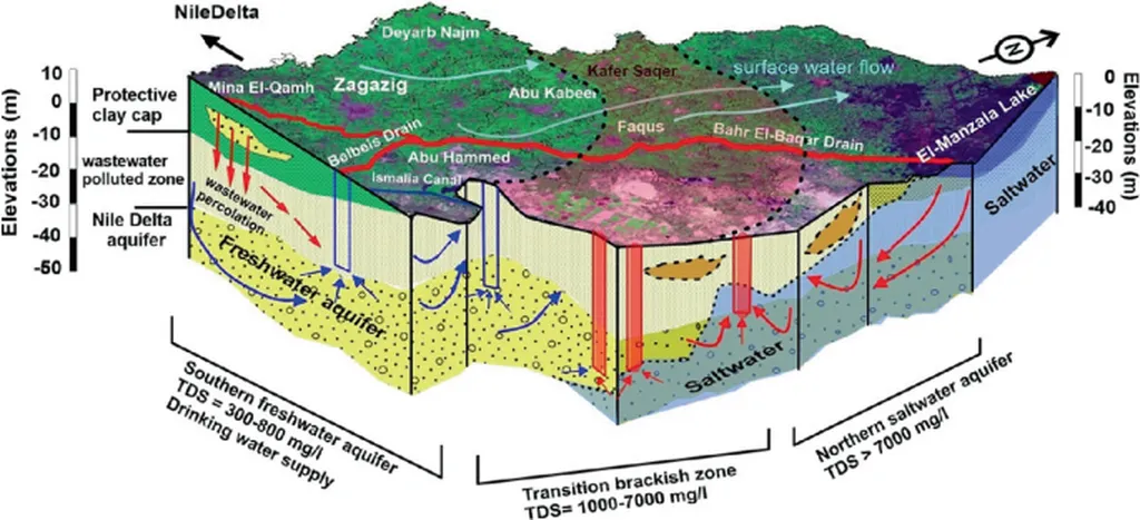
The challenge is daunting. The Nile Delta’s aquifers aren’t uniform; they’re stacked like geological lasagna—three distinct layers separated by confining clay beds. The top layer, the Coastal Holocene aquifer, is young and vulnerable to contamination. Below it lies the Late Pleistocene Nile Delta aquifer, a thicker, more productive zone. Deeper still is the Early Pleistocene aquifer, older and less tapped but critical for long-term resilience. Overseeing this system is no small feat. As Taher notes, “We’re not just dealing with water—we’re managing a living, breathing geological archive. Each layer tells a story of deposition, pressure, and human impact. To extract from it responsibly, we need to listen.”
The methodology Taher and his team developed is a masterclass in integration. It blends traditional fieldwork with cutting-edge technology: geophysical surveys to map underground structures, exploratory wells to ground-truth findings, and long-term monitoring to track real-time changes. But the real innovation lies in the combination of remote sensing, GIS mapping, and numerical groundwater modeling. By feeding this data into a calibrated model, the team could simulate how different extraction rates would ripple through the system over decades.
Why does this matter beyond the lab? Consider the desalination plant currently under construction in the region. Desalination is energy-intensive, but it’s also seen as a lifeline for water-stressed coastal communities. The plant’s raw water supply will depend on groundwater—specifically, the middle aquifer (Late Pleistocene). The model tested three pumping scenarios: 50,000, 75,000, and 100,000 cubic meters per day over 50 years. The results were telling. Moderate extraction (50,000–75,000 m³/day) proved sustainable, with minimal drawdown and manageable interference between wells. But pushing to 100,000 m³/day risked significant depletion, threatening both the aquifer’s health and the plant’s long-term viability.
For the energy sector, the implications are profound. Desalination plants are major electricity consumers, often powered by fossil fuels in regions like the Nile Delta. A poorly managed groundwater source could force operators to run plants at suboptimal levels, increasing costs and carbon footprints. Conversely, a well-characterized aquifer system enables precise planning—optimizing well placement, reducing energy waste, and ensuring that water supply aligns with energy demand.
Taher’s work, published in *Water Science* (Al-Ma’ al-‘Ilmi), offers more than technical insights; it provides a replicable framework for coastal regions worldwide grappling with similar pressures. From California to India, aquifers are being stretched to their limits. The study underscores a critical truth: sustainable groundwater management isn’t just an environmental imperative—it’s an economic one. In the Northeastern Nile Delta, the stakes are high, but the tools to meet them are now clearer than ever.