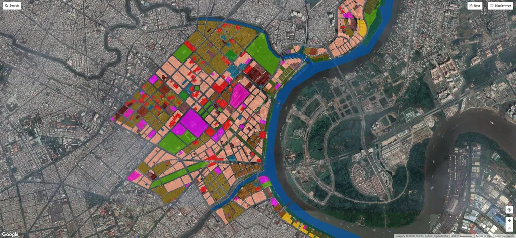
In the heart of Vietnam’s central region, where the Perfume River winds through the historic city of Huế, a quiet revolution in urban planning is unfolding—one that could reshape how cities worldwide manage growth, energy, and infrastructure. Led by Md Abdul Mueed Choudhury, a researcher at the Marche Polytechnic University in Italy, a new study published in the journal *Earth* demonstrates how freely available satellite data and advanced image analysis can give city planners a powerful, cost-effective tool to monitor urban landscapes in near real time.
Using data from the European Union’s Copernicus Sentinel-2 satellites, Choudhury and his team applied a Geographic Object-Based Image Analysis (GEOBIA) framework to classify land cover across Huế. Unlike traditional pixel-based methods, GEOBIA groups neighboring pixels into meaningful objects—like buildings, roads, or vegetation—before classification. This approach helps overcome the limitations of medium-resolution imagery (10–20 meters), which often struggles with small or complex features such as shallow water or fragmented farmland.
The results were striking: an overall accuracy of 91% in land-cover classification. “This isn’t just about mapping,” Choudhury notes. “It’s about enabling cities to make informed decisions on land use, resource allocation, and infrastructure development with a level of precision previously only possible with expensive commercial data.”
For energy companies and urban developers, this scalability is transformative. Cities in rapidly urbanizing regions—where traditional ground surveys are costly and slow—can now use Sentinel-2 data and GEOBIA to track changes in built-up areas, green spaces, and water bodies over time. This real-time monitoring can inform strategic decisions on where to expand power grids, site renewable energy projects, or protect critical ecosystems.
While the method excels at identifying broad land classes like vegetation and built-up surfaces, it still faces challenges with small or spectrally mixed features. “Shallow water and fragmented rice paddies remain tricky due to mixed-pixel effects,” Choudhury explains. “But even here, the framework offers a strong baseline—one that can be refined with higher-resolution data or local calibration.”
What makes this research particularly compelling is its replicability. The framework isn’t tied to Huế’s unique geography. With minor adjustments, it can be deployed in cities across Southeast Asia, Africa, or Latin America—regions where rapid urbanization is straining resources and infrastructure. For energy planners, this means better forecasting of demand hotspots, more accurate siting of solar or wind farms, and smarter grid expansion.
As cities worldwide seek sustainable growth, tools like GEOBIA and open-access satellite data are becoming indispensable. They don’t just map the present—they illuminate the path to a more resilient, data-driven future.